Paul da Serra Plateau: Heart of Madeira’s Highland
Madeira’s high plateau where wind, water, and legends converge.
Good To Know
Introduction
On the western part of Madeira Island, far above the subtropical coastlines, a windswept upland anchors the island’s water supply and holds many stories. Paul da Serra (often spelled Paúl da Serra) is the largest plateau in the Portuguese archipelago of Madeira, lying around 1,300–1,500 m above sea level and covering roughly 20–24 km². With its flat expanses, low vegetation and cool air, the high plain contrasts sharply with the steep volcanic slopes and lush coastal valleys below. Because the plateau collects rainfall, fog and meltwater like a sponge, it feeds streams, levadas (irrigation channels) and hydroelectric dams that are vital for agriculture and electricity generation. Yet Paul da Serra is more than a hydrological engine. Its history intertwines with early exploration, the construction of levadas through sheer cliffs, clandestine brandy smuggling across the island, and today’s energy transition with wind farms. This article presents a comprehensive 5000‑word narrative about Paul da Serra, exploring its geography, climate, ecology, human history, smuggling era, infrastructure, tourism and cultural significance.
Geographical and Geological Overview
Location and Topography
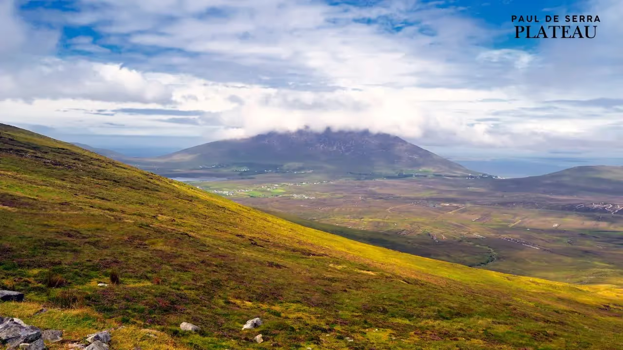
Paul da Serra sits in the west–central part of Madeira, roughly 33 km northwest of Funchal, the island’s capital. The plateau stretches about 20 km from east to west and between 3–4 km from north to south, giving it an area around 24 km². Unlike most of Madeira, which is sculpted by deep ravines and precipitous peaks, Paul da Serra is mostly flat. The plateau resembles an undulating plain of rolling hills and shallow basins carved into layers of volcanic basalt. Its average altitude is around 1,500 m, with the highest point at Pico Ruivo do Paul (1,640 m), followed closely by Bica da Cana (1,620 m). On clear days, the plateau affords panoramic views across both the north and south coasts. The relative flatness is so unusual in Madeira that locals often call it the island’s only “tabletop” or “grassland” amid mountains.
The plateau developed on a series of lava flows that erupted during Madeira’s shield‑volcano phase about 1–2 million years ago. Layers of basalt cooled and solidified into horizontal strata, later uplifted and gently tilted by volcanic forces. Erosion by wind, rain and freeze–thaw cycles gradually planed the surface, producing the present undulating plain. At its edges, the plateau breaks off into high cliffs and deep valleys such as the Ribeira da Janela and the Rabaçal valley. In these cliffs one can see prismatic disjunctions—vertical columns that form as lava cools and cracks—bearing witness to the island’s volcanic origins. In some places, erosion has sculpted caves and tufa layers that, according to a nineteenth‑century traveller, were once used as shelter and suggested an old smuggling trade.
Hydrological Basin and “Giant Sponge”
Geographers describe Paul da Serra as a “giant sponge”, because its porous volcanic soils and shallow depressions absorb rainfall and fog that falls on the plateau. During winter the flat surfaces often flood, creating temporary lagoons and marshes. Water infiltrates into the underground aquifers rather than running off immediately, which allows slow release to springs and streams that feed Madeira’s levadas and reservoirs. In summer, when the plateau dries, some of this water evaporates from the marshes, while the remainder continues seeping into the groundwater system. Because of this hydrological function, Paul da Serra is considered the most important groundwater recharge area in Madeira.
Peaks, Viewpoints and Accessibility
Despite its generally flat nature, the plateau is ringed by higher points that offer spectacular vistas. Pico Ruivo do Paul at 1,640 m crowns the plateau and marks the meeting of several walking paths. Nearby is Bica da Cana (1,620 m), a viewpoint accessible by car that overlooks the verdant valleys of the north coast and the Laurissilva forest. On days when low clouds drift below the plateau, visitors can see a “sea of clouds” while standing in brilliant sunshine. Other high points include Pico do Paul (a minor summit around 1,640 m), Estanquinhos and Pico de Chão da Ribeira. The plateau can be reached via the regional road ER110 from both the north and south coasts; the trip from Funchal takes about an hour and climbs through eucalyptus forests and steep switchbacks.
Wind and Weather
Strong, steady winds sweep across Paul da Serra throughout the year. The open plain lacks the sheltering valleys that characterise other parts of Madeira, so Atlantic trade winds flow unimpeded over the plateau. This continuous breeze has made the area ideal for wind farms. Modern turbines dot the landscape and contribute to Madeira’s electricity supply. The winds also help to cool the plateau; average temperatures are lower than on the coast, with cool nights even in summer. Mists often envelop the plain as moist air from the ocean condenses, leading to “occult precipitation”—water deposition from fog—accounting for about 8 % of total precipitation and up to 33 % during dryer months.
Climate and Hydrology
Rainfall, Fog and Occult Precipitation
The climate of Paul da Serra is markedly different from the subtropical weather along Madeira’s coast. Situated around 1,300–1,500 m, the plateau lies within the cloud zone where moist Atlantic air meets cooler upland temperatures. Annual rainfall is high, and fog is a frequent companion. As moist air rises and cools over the plateau, tiny droplets condense on vegetation, rocks and man‑made structures. This fog drip, called occult precipitation, can add up to 8 % of the total annual moisture and as much as one‑third in drier periods. Occult precipitation, combined with rainfall, keeps the plateau moist even during the dry summer. The constant humidity fosters carpets of heather and grasses, but it also makes the ground boggy and slippery.
Water Storage and Levadas
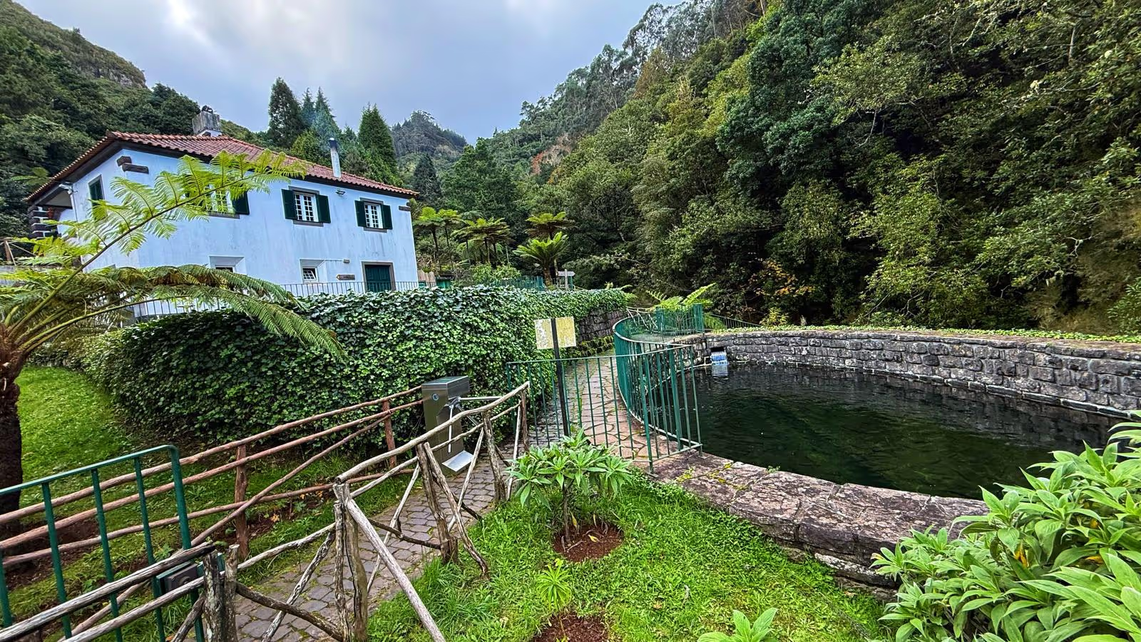
Paul da Serra’s role as a water collector underpins Madeira’s levada system, a network of irrigation channels dating back to the fifteenth century. The plateau gathers water from rainfall and fog; this water then feeds springs and reservoirs that supply levadas running toward agricultural terraces and villages on the coast. Many of the island’s famous levada walks—such as the Levada das 25 Fontes (Levada of 25 springs) and Levada do Risco—begin at Paul da Serra. An arm of the Levada do Alecrim passes through tunnels of heather and along the Ribeira do Alecrim, a stream that supplies the Calheta hydroelectric station, one of Madeira’s major power plants. The Lagoa do Vento waterfall, about 80 m high, sits in the Rabaçal valley and is fed by basaltic rock formations showing prismatic disjunction.
In winter the plateau’s shallow depressions fill with water, forming temporary lakes and bogs. For centuries local shepherds have led cattle to these seasonal pools. During spring melt, streams flow into deep ravines such as Ribeira da Janela and Ribeira da Urze, cascading over waterfalls before being channelled into levadas. Early engineers carved channels along the sides of cliffs, sometimes digging tunnels through solid rock, to divert water to the south coast. A nineteenth‑century traveller described the construction of the Rabaçal levada: labourers had to carve a channel into a 1,000‑ft (about 305 m) high rock and planned to bore a tunnel through the end of Paul da Serra for a six‑mile‑long levada. Initiated in 1836, the project stalled due to lack of funds, leaving water to continue tumbling into the northern valleys and depriving southern vineyards of irrigation. This anecdote illustrates the technical challenges of harnessing water from the plateau.
Hydroelectric Dams and Reservoirs
Today, water collected on Paul da Serra powers the Calheta Hydroelectric Plant. Water from streams like the Ribeira do Alecrim is stored in a reservoir near Rabaçal and diverted through pipelines to turbines that generate electricity. Because the plateau receives abundant rainfall and fog, its water supply is relatively reliable, but climate change and reduced precipitation have prompted concerns about future availability. In the 2010s, Madeira built a new reservoir on Paul da Serra to store pumped water and stabilise supplies during dry spells. Nevertheless, hydroelectric production accounts for only about 20 % of the island’s electricity; the rest comes mainly from thermal plants, with wind farms on Paul da Serra helping to increase the share of renewable energy.
Flora and Fauna
Vegetation: Heather, Broom and Endemic Species
When settlers first arrived in Madeira in the fifteenth century, the highlands were covered by dense Laurissilva forest—a mix of evergreen trees such as laurel (Laurus novocanariensis), til (Ocotea foetens), and barbusano (Apollonias barbujana). Deforestation for timber and grazing gradually pushed the forest back, and the plateau became an open landscape dominated by heather, broom and grasses. Erica arborea (tree heather) and Erica scoparia form thickets up to 3 m high at the edges of Paul da Serra. In exposed areas, low mats of juniper (Juniperus oxycedrus) and thymus (Thymus micans) cling to the ground. The plateau is one of the few places where this endemic thyme thrives; its tiny pink flowers scent the air in late spring. Other endemic plants include Vaccinium padifolium (blueberry), Calluna vulgaris (ling) and Festuca jubata (tufted fescue). Since grazing decreased in recent decades, natural vegetation is slowly recolonising the plateau.
Seasonal wildflowers brighten the plain. In summer, yellow broom (Cytisus scoparius) and purple heather paint the slopes. After rainfall, mosses and liverworts turn the ground emerald green. In autumn, berries attract birds such as the Madeira chaffinch and the goldcrest. The plateau’s open grasslands also host cows and sheep that roam freely, giving the landscape a pastoral character. The combination of endemic vegetation and pastoral use creates a unique mosaic of habitats.
Wildlife
Fauna on Paul da Serra is less diverse than in the Laurissilva forest but still includes notable species. Birds adapted to highland conditions—such as the Madeiran chaffinch (Fringilla coelebs maderensis), spectacled warbler and grey wagtail—forage among the heather. Raptors like the buzzard circle above searching for rabbits. In recent decades the Madeira freira (Zino’s petrel), an endangered seabird, has been observed flying over the plateau during breeding season. Small mammals include feral rabbits and rodents. Sheep and cattle have long grazed here, though numbers have declined as agriculture shifted to more profitable crops. The plateau’s cold, damp climate reduces the presence of reptiles and insects found on the warmer coasts.
Early Human History and Settlement
Pre‑colonial Period and Discovery
Before Portuguese explorers arrived in the early fifteenth century, Madeira was uninhabited. The island’s discovery is traditionally attributed to João Gonçalves Zarco and Tristão Vaz Teixeira around 1419–1420. Their expeditions led to the colonisation of Funchal and the cultivation of sugar cane in the coastal lowlands. The highlands, including Paul da Serra, remained largely untouched during the first decades of settlement because the climate was colder and the terrain difficult. The plateau’s altitude made it unsuitable for sugar cane, grapes or cereals. However, it provided rich pastures for cattle and sheep; early settlers used it as communal grazing land, and local shepherds built simple shelters and enclosures.
Shepherds, Hunters and Early Paths
By the sixteenth century, pathways crossed Paul da Serra linking northern parishes such as São Vicente and Seixal with southern communities like Ponta do Sol. Shepherds followed ridges and valleys to move livestock and barter goods. Hunters pursued rabbits and birds across the moor. Because the plateau collected water, some early settlers dug ponds and reservoirs to water animals. Over time, these trails developed into routes that later served contraband smugglers. The 1851 travelogue A Sketch of Madeira described ascending from the north via a steep, rocky road to reach Paul da Serra, illustrating the ruggedness of early paths.
Early Engineering and the Rabaçal Levadas
As Madeira’s population grew, so did the need to irrigate land on the drier south side. In the nineteenth century, engineers planned to channel water from the wet north across Paul da Serra to the south. One such project was the Rabaçal levada, started in 1836. According to Edward Vernon Harcourt’s 1851 account, workers carved a channel in a 1,000‑foot high rock and intended to bore a tunnel through the end of Paul da Serra to build a six‑mile levada. After some progress the project halted due to financial difficulties This early attempt foreshadowed later successes in water management, but also underscores the harsh conditions and limited resources of the period. In the following decades, numerous levadas were completed around the plateau, bringing life‑giving water to banana plantations and vineyards.
Engineering and Water Management
Levadas of Rabaçal and 25 Fontes
The area of Rabaçal, on the southern edge of Paul da Serra, contains some of the island’s most famous levada trails. From a small station on the plateau, visitors descend by shuttle or foot into a valley draped in Laurissilva forest. Here two levadas dominate: the Levada do Risco, which follows the escarpment to a high waterfall, and the Levada das 25 Fontes, which leads to a glen where 25 springs tumble over mossy cliffs into a pool. Along the Levada do Alecrim, walkers traverse tunnels carved through dense heather and follow the Ribeira do Alecrim, a stream feeding the Calheta hydroelectric plant. These levadas exemplify centuries of engineering: carved by hand, built with stone walls and wooden flumes, and maintained by local communities.
Hydroelectric Power and Reservoirs
During the twentieth century, water management at Paul da Serra moved beyond irrigation to electricity generation. The Calheta Hydroelectric Station, inaugurated in 1954, uses water captured on the plateau to spin turbines near the coastal town of Calheta. A large tank near Rabaçal stores the captured water before it descends through penstocks. Additional hydroelectric stations north of Calheta contribute to the island’s grid, but limited storage and declining rainfall have reduced hydropower’s share of electricity to about 20 %. To supplement supply, the regional government built new reservoirs and pumping stations on the plateau in the 2010s. During times of excess electricity, turbines run in reverse to pump water back to the reservoir; during peak demand, water flows downhill to generate power.
Wind Farms
Paul da Serra’s constant winds make it the logical site for wind energy. Turbines erected since the early 2000s form a “forest of windmills” across the plateau. This wind energy helps offset reduced hydropower and decreases reliance on fossil fuels. The high plateau is accessible by road, allowing maintenance crews to service the turbines. From a distance the spinning blades contrast with the natural landscape, but local authorities view them as part of the island’s renewable energy strategy. The presence of both hydroelectric and wind power illustrates Paul da Serra’s dual role in Madeira’s water and energy security.
Smuggling and Contraband: The Brandy Trade
Early Hints of Smuggling
Smuggling has long been part of Madeira’s highland lore. In an 1883 travel narrative, Richard F. Burton observed caves hollowed into tufa layers along the cliffs around Paul da Serra. The multiple doors and compartments suggested that locals had used these shelters for an “old smuggling trade”. While details are scarce, these hints indicate that contraband goods—perhaps wine, sugar or other taxed commodities—moved across the plateau well before the twentieth century. Madeira’s geographic isolation and rugged terrain offered ideal conditions for hiding goods from customs officials.
Laws, Embargoes and the Growth of Contraband
Contraband increased when authorities attempted to regulate Madeira’s spirits. After 1821 the island faced restrictions on importing foreign brandy; only local distillers could produce aguardente (a sugar cane spirit). According to a historical dictionary of Madeira, the only way to circumvent the embargo was through contraband; prohibitive laws from 1822 encouraged the proliferation of clandestine distilleries
localhost. By the early twentieth century, production of sugar cane declined and many distilleries closed, but islanders continued to demand spirits. In 1927, 34 sugar‑cane mills shuttered, leaving a vacuum that led to clandestine production of brandy from wine lees. Distillers operating in hidden valleys produced a potent drink that provided income for poor families and served as a symbol of independence.
The Smuggling Route Across Paul da Serra
To transport contraband brandy from the north to the south coast, smugglers created networks of secret paths. The Rota do Contrabando (“Smuggling Route”) is not a single trail but a combination of paths designed to avoid authorities. The general route began in the northern village of Seixal, where wine lees were distilled into aguardente. Carriers, often young men, loaded 50‑litre barrels onto their shoulders and climbed through the lush valley of Chão da Ribeira before reaching Terra Chã on the edge of Paul da Serra. From there, they passed Fontes Ruivas, Pico Ruivo do Paul and Estanquinhos, then crossed the plateau to Bica da Cana. After descending through Fajã Redonda, Pedras, Sítio da Quinta, Jangão, and Lombada, they arrived at Ponta do Sol on the south coast. The smuggling expedition covered about 25 km and required climbing from sea level to 1,500 m and back down steep slopes.
Carriers usually travelled at night or during foggy weather to avoid detection. They walked in small groups, using codes and whistles to communicate. When patrols were reported, smugglers detoured onto less obvious tracks, hiding barrels in caves or burying them under bushes. Because the loads were heavy, some used donkeys or oxen on the more accessible sections. Despite the dangers, smuggling offered modest profit; carriers could sell a barrel of aguardente for much more than they earned in agriculture.
Social and Cultural Impact
The smuggling era lasted roughly 50 years, from the late 1920s until the 1970s. During this time, contraband brandy became woven into local culture. Stories of clever smugglers outwitting revenue officers filled taverns; songs and poems celebrated their bravery. The practice provided an economic lifeline for many families during times of poverty. At the same time, authorities saw contraband as a threat to revenue and moral order. They periodically increased patrols, captured and punished smugglers, and attempted to destroy hidden stills. When Madeira’s economy improved and legal alcohol production expanded, the incentive for contraband diminished. Today the smuggling route has been revived as a hiking trail that commemorates this chapter of island history. Cultural associations such as RETOIÇA organise walks and events along the old paths, highlighting the ingenuity and hardships of those who carried brandy across Paul da Serra.
Wind Energy and Modern Infrastructure
Transition to Renewables
As global energy priorities shifted toward renewable sources in the late twentieth century, Madeira looked to its highlands for solutions. The plateau’s steady winds attracted engineers who erected dozens of turbines. Visitors approaching Paul da Serra from the south see rows of white towers with three slender blades rotating in the breeze. The turbines harness the kinetic energy of the Atlantic winds and feed electricity into the island’s grid. Given that hydropower now supplies only a fifth of Madeira’s electricity, wind energy is a crucial supplement. Recent projects have increased total wind capacity significantly, reducing dependence on imported diesel for thermal plants. The presence of turbines also symbolises Madeira’s commitment to sustainable development.
Infrastructure and Access
Modern infrastructure on the plateau includes not only wind farms but also new reservoirs, pumping stations, transmission towers and paved roads. The regional road ER110 crosses Paul da Serra east–west, linking Funchal to Porto Moniz and Santana. Secondary roads branch off to viewpoints, picnic areas and hiking trailheads. A network of unpaved service roads provides access to wind turbines and reservoirs. Visitors find few buildings or villages on the plateau; only scattered farmhouses and shepherd shelters dot the landscape. The absence of urban development preserves the plateau’s open character but also exposes it to harsh weather.
Tourism and Recreation
Hiking and Walking Trails
Paul da Serra is a popular destination for hikers and nature lovers. Its flat terrain offers easier walking than the steep levadas, while surrounding valleys provide more challenging descents. Among the most famous trails starting from the plateau are the Levada das 25 Fontes and Levada do Risco, both descending into the Rabaçal valley. The Vereda do Fanal leads across ancient woodland to a mystical laurisilva forest filled with gnarled til trees and moss. Hikers on the PR7 – Levada do Alecrim enjoy heather tunnels and views over the Ribeira do Alecrim and the Lagoa do Vento waterfall. The Smuggling Route has been recreated as a long‑distance walk connecting Seixal to Ponta do Sol; guided tours recount stories of contraband and stop at historical sites.
Nature Observation and Stargazing
The plateau’s open skies and minimal light pollution make it ideal for stargazing. On clear nights, the Milky Way is visible, and the cool air improves transparency. During the day, birdwatchers look for raptors soaring on thermals and small passerines in heather thickets. In spring and summer, botanists study carpets of wildflowers, while in autumn, local families pick wild berries. The presence of free‑roaming cows and sheep adds to the rural atmosphere.
Challenges of Tourism
While tourism brings economic benefits, it also poses challenges. Off‑road vehicles and hikers can damage fragile vegetation and erode trails. Litter and campfires risk wildfires. The regional government has implemented measures such as visitor centres, signposts, and restrictions on vehicle access to protect sensitive areas. Tour guides emphasise “leave no trace” ethics. By promoting sustainable tourism, Madeira hopes to balance the plateau’s popularity with conservation.
Cultural Significance and Folklore
Pastoral Life and Community Traditions
For centuries the plateau has been associated with pastoral traditions. Shepherds from neighbouring parishes bring cows and sheep to graze on the rich upland grasses during summer. Communal shepherding fostered cooperation; farmers shared watering holes and built corrals. Seasonal festivals sometimes included trips to Paul da Serra, where families camped and roasted meat. Oral histories recall evenings spent around bonfires telling stories of ghosts, treasure and smuggling. Although modernisation has reduced pastoralism, some families still practice transhumance, reflecting a living connection to the land.
Legends and Beliefs
Paul da Serra’s misty, windswept landscape has inspired legends. Locals speak of fantasmas (ghosts) roaming the moors at night, of hidden gold buried by smugglers, and of mysterious lights leading travellers astray. One tale recounts a shepherd who encountered a procession of hooded figures carrying a coffin across the plateau; upon returning home he found a relative had died at the same time. Such stories reflect the fear and respect with which people regarded the highlands. They also highlight how isolation and harsh weather can heighten imagination.
Conclusion
Paul da Serra is much more than a geographic curiosity on a tropical island; it is the hydrological heart, renewable energy hub, historical stage and cultural canvas of Madeira. Its flat plateau collects rainfall and fog, recharging aquifers and feeding levadas that irrigate vineyards and banana plantations. Its basalt layers record volcanic origins and create dramatic cliffs with prismatic disjunctions. The wind that sweeps across it spins turbines and shapes clouds. The plateau’s history includes heroic engineering projects like the Rabaçal levadas and clandestine smugglers who carried barrels of brandy across the island. Today it hosts hikers, wind turbines and reservoirs while still offering solitude and mystery. Preserving Paul da Serra’s environment and remembering its stories ensures that this unique landscape continues to nourish both the body and the spirit of Madeira.
Highlights
The only pass you need in paradise